Cast away
Britain’s newest island is forming off the Yorkshire coast. We roll up our trousers to find out how the North Sea has eaten a huge chunk out of Spurn Point
An enormous Unimog growls and bumps across a narrow strip of beach, leaving a wake of deep ruts in the sand. The military-green 4×4 looks like it could be an amphibious landing craft – and, indeed, the vehicle was once owned by the Dutch army. However, the two dozen or so people seated in rows six feet above the beach are not a squad of invading soldiers but a party of day trippers.
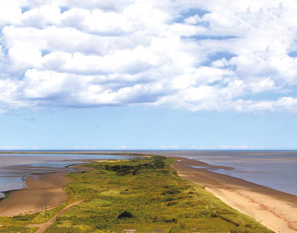
They have bought tickets to see, among other things, the damage wreaked by one of the most destructive North Sea tides ever recorded. On the night of 5 December 2013, a perfect storm developed off the coast of Northern Scotland. As it pushed out across the North Sea, a tidal surge swept down the east coast of the UK and slammed into Spurn Point, a three-and-a-half mile-long spit of sand dangling like a hook in the wide mouth of the Humber Estuary.
Geologists have long predicted that one day it will disappear for good
Uniquely in Europe, the narrow peninsula is so fragile that, several times since the Middle Ages, it has actually been washed away by sea erosion. And yet, incredibly, it has always managed to rebuild itself by accumulating silt. Geologists’ drawings of this now-you-see-it-now-you-don’t behaviour look like time-lapse photography of a wagging finger.
Now, the process seems to have started once again. By the time the storm’s wall of water had reached the Yorkshire coast that December night, it was already high tide. Swollen by more than six feet in height and driven by a massive swell, it cut Spurn in two. Which is why Andrew Mason, driver of the big Unimog, begins his running commentary for the party of tourists with the words: “Welcome to the newest island in the British Isles.”
It’s low tide on this run of what is advertised as the Spurn Safari, and so the end of the peninsula is accessible. As Mason drives south, the grey North Sea lies on one side of the beach, while a short distance away on the other side are the adhesive brown mudflats of the Humber. Not every high tide cuts off Spurn – yet. Depending on weather conditions, there are still many occasions when the gritty seawater reaches across the beach and runs straight through into the estuary, leaving a mile-long stretch of the peninsula out of bounds and effectively turning Spurn into an island.
Geologists have long predicted that one day it will disappear for good, but reports of Spurn’s demise have, as yet, failed to come to fruition. However, this time it might be different. The storm moved a large section of the peninsula almost 80 yards to the west, ripped out the road built by the army during the construction of a World War I fort, and forced Associated British Ports to relocate its vital VTS navigation service – which guides cargo vessels through treacherous sandbanks of the Humber – from Spurn to Grimsby.
Andrew Mason is employed as Spurn heritage officer by the Yorkshire Wildlife Trust, which owns the peninsula and runs it as a nature reserve. He was present the night the tide destroyed the road and created Spurn Island, and gives thanks that the wind wasn’t coming from the North East. Although the media’s attention would have focused on the likely devastating impact such a tidal surge would have had on London, that would have meant a much greater catastrophe for Spurn, he says.
Still, the damage wreaked on Spurn is humbling to look at. The strip of land which carried the single-track road is now a sand and shingle beach; its hard surface has almost entirely disappeared. Around 200 yards of land now remains at low tide between the North Sea and the Humber.
Numerous signs warn visitors against crossing this mile-long washover zone and about the perils of high tide, when four-foot-deep water separates the end of Spurn from what must now be called the mainland. At such times, the signs read, the route is “extremely dangerous”. Visitors are told not to cross the sand and never to walk through waves or standing water.
For those who get stranded on the island, an emergency shelter has been provided, and whenever there is a spring tide and the water level rises the Yorkshire Wildlife Trust mounts a patrol. But, Mason sighs, there is always one idiot who is prepared to take a risk. Not long ago, a visitor decided to try and make the crossing despite having been told not to, and nearly came to grief.
Spurn’s importance isn’t simply as a geological curiosity and nature reserve. The UK’s only full-time lifeboat crew is stationed near the tip, with a large area of the North Sea to cover. Because of the erosion, the island’s only inhabitants and their families have been forced to move from a cluster of houses next to the base.
Spurn also offers important physical protection for Humber shipping. Each tide pumps 1,500 tones of muddy sediments into the estuary, originating from erosion further up the Yorkshire coast, but without Spurn that figure would vastly increase and create chaos for cargo vessels. The Humber ports handle goods worth £2.2 billion a year, with Immingham on the south bank currently having the UK’s largest docks, while Hull is also home to the east coast’s burgeoning offshore wind farm industry. Any changes to sandbanks at the mouth of the Humber could have a devastating economic impact.
For decades, geologists have struggled to answer the question of whether Spurn might once again disappear. The Environment Agency recently commissioned a study which concluded this was unlikely, but correctly forecast that the sea would one day breach the narrow part of the peninsula. But no one predicted it would be so soon.
Mason believes that yet more land will be reclaimed by the sea, since the decision has been taken not to patch up sea defences. He points out further stretches of road which have collapsed, and other places which are considered vulnerable to the sea in the next decade or so.
For as long as it survives, there will always be fascination with Spurn, which featured in the 2014 BBC series Seven Wonders. It is still the best place on the east coast for watching bird migration – to birdwatchers what York railway station is to trainspotters. Since the storm of 2013, the Yorkshire Wildlife Trust has turned adversity into opportunity by mounting the popular Spurn Safaris and opening up the lighthouse and wartime fort to visitors.
Mason remains philosophical. Spurn is simply being controlled by nature, he says, rather than conforming to the shape imposed on it by man-made sea defences. “We are a nature reserve, and nature is dictating what we do rather than the other way round. I like that, actually.”
For Spurn Safari booking information, email info@ywt.org.uk or call 01904 659570

Leave a reply
Your email address will not be published.